Tag Archives: landscape

A nice surprise

When I wrote about Father Crowley Overlook a couple weeks ago, I realized I had several promising Death Valley images in my  archives that I’d never processed.  A trip like that can be overwhelming, and dealing with so many photos takes time and effort.  I suppose back then I picked out ones I thought were best and left the rest for later.

Well this week I went back, found this one I liked, and worked on it.

Shifting sun, shadows, and sandShifting sun, shadows, and sand – early morning at Mesquite dunes in Death Valley.

This scene is looking roughly north about 15 minutes after sunrise.  The low sun angle makes for lovely contrasts and colors, and helps emphasize the shapes and textures of the dunes.

While I was working on this in Lightroom, I noticed something on the far sand dune, just below the shadow at the top. Please click on the image below so you can see it better.

.                                                                  The hidden surprise!

I was making landscape images, so I used a 24-120mm lens and fortunately liked the framing at 120mm.  My Nikon D800 camera had a 36 MP sensor and captured a great deal of information in the file.  Even though it’s at the limits of resolution, you can definitely tell there’s something there – tracks in the sand and one (maybe two?) animals!

A photo like this is a good example of something I wrote about 10 years ago: Photographic “Level of Detail”.  Looking at it from a distance, you see colors, shapes, shadows and lines.  Zoom in a bit and textures, tracks, and other details become visible.  Zoom in all the way and you can spot wildlife.  How cool is that?!

I really enjoy this aspect of photography.  Have you ever discovered something like this in one of your images?

You can view my other DVNP photos here.  Thanks for stopping by and reading my blog. Now, go make some photos – it’s can be surprising!

©2019, Ed Rosack. All rights reserved

Back to nature

It seems like ages since I’ve been out amongst our natural Florida wonders.  So I was eager to visit Merritt Island National Wildlife Refuge last week for a look ’round.  I stopped first by the Indian River before dawn.  The geometry of the pier, bridge and sun rays teamed up to form nice leading lines toward the pending sunrise.

A peaceful morning on the pier by the bridgeA peaceful morning on the pier by the bridge – Veterans Memorial Fishing Pier by the Max Brewer Causeway in Titusville, Florida

East Gator Creek road was closed, so I drove up to Haulover Canal and the Mantee Observation Point – of course there were no manatees visible there!  Then I circled back to Black Point Wildlife Drive.

Standing birdStanding bird – Tri-colored Heron on a bush. It was so still that I had time to zoom in and make a three frame vertical panorama.

We’ve had lots of rain lately and there was plenty of water at Black Point.  I saw fish schooling in several spots, although for some reason the birds weren’t interested. I think the highlight of the trip for me was watching two Reddish Egrets dancing over the water.

Running birdRunning bird – a prancing Reddish Egret seems to walk on water

There were just a couple other people on the drive and I only saw them briefly.  It’s a special privilege to have a place like this mostly to yourself – even at this time of the year when it’s so hot and the wildlife is a bit sparse.

Flying birdFlying bird – a Great Egret glides above the water

What a delightful morning!  I have many more MINWR photos here.  Thanks for stopping by and reading my blog. Now, go enjoy nature – it’s good for you!

©2019, Ed Rosack. All rights reserved

F-18 jet exiting "Star Wars Canon" into Death Valley at Father C

Father Crowley Overlook in Death Valley NP

You may have seen the tragic news last week about a US Navy F18 crash in Death Valley.  The jet was flying through Rainbow Canyon next to Father Crawley Point when it hit, killing the pilot and injuring seven bystanders.

I feel a connection to this.  One reason is because of my own Navy service.  During NROTC training, I was assigned to an attack squadron aboard an aircraft carrier in the Mediterranean.  I saw firsthand how professional, dedicated and skilled Navy aircrews are.  My heart goes out to the pilot’s family.

I also feel connected because I’ve visited that exact spot. Back in 2015, Tom M. and I drove up to Father Crowley Point during a trip to Death Valley and made a few photos.  At the time, we weren’t aware of the background of this place and just planned to make landscape photos.  But then we heard the jets overhead.

F-18 jet exiting "Star Wars Canyon" into Death Valley at Father Crowley Point, October 2015US Navy F-18 exiting “Star Wars Canyon” in Death Valley at Father Crowley Overlook, October 2015

Air Force and Navy pilots have trained there since the 1930s and it’s become a hotspot for military aircraft photographers and enthusiasts (see this article in the LA times). Rainbow Canyon has a couple of nicknames:  “Star Wars Canyon” and the “Jedi Transition”.  It’s one of the few places in the world where you can see and photograph military aircraft below you as they fly by (here’s another good article on Arstechnica).

Tom and I were getting ready to move on when we heard another jet approaching and getting much louder.  I managed to switch to continuous mode and follow with my camera as it roared through the canyon right next to us.  The photo above is a 9 frame sequence merged into a single image to show the progression as it leaves the canyon.  I’d only ever processed a single frame of it before (here on Flickr).  Although this set of frames is from a more recent (and capable) camera, I went through processing steps similar to those I described here:  Reprocessing-a-mt-evans-elk-herd-panorama.  I merged it manually this time to make sure all images of the aircraft were preserved in the final version.

I have other Death Valley blog posts here: https://edrosack.com/2015/11/01/death-valley-national-park-california/, here: https://edrosack.com/2015/11/15/death-valley-addendum/, and here: https://edrosack.com/2015/10/25/night-sky-in-death-valley/).  And you can view my other Death Valley photos in this set: https://www.flickr.com/photos/edrosack/albums/72157657912609623.

I’m glad bystanders’ injuries weren’t too serious. I feel very sad for the young pilot and his family.  And I’m grateful that we have people that volunteer to serve and protect us, even at such great risk to themselves.

Thanks for stopping by and reading my blog. Now – go thank someone in the military for their service.

©2019, Lynn and Ed Rosack. All rights reserved

Flying Home

Lynn and I flew up to Wisconsin for a wonderful visit with Mike, Sara, and Calvin last weekend.  Just before landing back in Orlando, the sky lit up.  Lynn had the window seat and was making many photos, and she made a few for me too.

Almost home 2Almost home – a lovely sunset on our way in to Orlando from Wisconsin

Before I gave her my iPhone, I opened the Lightroom Mobile App and set the file format to RAW DNG.  When I got home I processed it in Lightroom and Photoshop.  I think it’s very nice for a grab shot through a thick window!

If you have a recent generation phone, you should look into using RAW format, especially for scenes like this.  It records much more information and gives you adjustment room in your post processing, especially when changing white balance and recovering highlights and shadows.  It’s well worth it!

We’re both a little under the weather after our trip, so that’s all I have for you this week.

Thanks for stopping by and reading my blog. Now – go make some RAW photos!

©2019, Lynn and Ed Rosack. All rights reserved

Howell Creek

Howell Branch creek starts at Lake Maitland and flows into Lake Waumpi.  From there it’s called Howell Creek as it goes through Lake Howell and then wanders east and north  to empty into Lake Jessup. It passes within a half mile of our home in Winter Springs.

I’ve driven by this spot below in Maitland many times, but didn’t realize it’s on the same waterway:

Howell Creek No. 2Howell Creek – Where it crosses Lake Howell Road.  A small dam there creates a lovely little waterfall / rapid.  I’ve driven by it for years and finally made a photo.

I never stopped before because there’s no obvious parking nearby.  But Lynn volunteered to drive me over, drop me off (and come back and pick me up too!).  So off we went…

My plan was to make a few images from down near the water with a wide angle lens, maybe up close to the dam.  But several  “No Trespassing” signs scuttled that. I stayed up on the bridge by the road and made my images from there.  I’m glad I brought my 24 – 200 mm (eq.) lens too – the reach came in handy!

Several people walked by while I was there and mentioned how pretty the view is.  They talked about wading birds and the otter family they see there.  I didn’t see any otters, but a Great Egret eventually wandered into my frame.  I was lucky it stayed still while I made a long  exposure to blur the water.  When Lynn saw the photo, she thought it needed a dark colored bird – I should’ve waited for an anhinga!

Wind caused some blurring in the leaves and Spanish moss.  I was also worried the vibration caused by trucks on the road behind me would shake my tripod and blur things.  I made several frames just in case and this one came out pretty well.

Research indicates there was a water powered mill located just up stream from this dam in the mid 1800s.  And I found an old article in the Orlando Sentinel, saying that the first dam in this spot was built around 1900. One story says residents blew up the dam during a hurricane and replaced it later.  Apparently, a more durable one was built in  the 1950s and was replaced by the current dam in 1979 when Orange County widened Howell Branch Road.

It doesn’t seem like I’ve used other photos of Howell Creek in the blog before, so I’ll end this post with two older images from closer to our home in Winter Springs.

Howell CreekHowell Creek infra red (October 2013)

Howell CreekHowell Creek bed and reflections (October 2013)

Thanks for stopping by and reading my blog. Now – stop somewhere you’ve been passing by and make some photos!

©2013 and 2019, Ed Rosack. All rights reserved

Reprocessing a Mt. Evans Elk Herd panorama

Back in July of 2007, I wrote a post about Mt. Evans, Colorado and included this image of an Elk herd we saw there:

Elk herd near mile marker 8 on Mount Evans  (2007 version)

At that time, I was using a Nikon D80 camera and made this photo with an entry level 70-300 telephoto lens.  I remember wanting to capture as much detail as possible, so instead of making one exposure of the whole herd, I zoomed in as far as I could and made four different frames at 300mm (450mm eq.), f/5.6, 1/100 sec, and iso 100. I ran across these images in my photo archive recently and wanted to see if I could reprocess the RAW files for a better result.  I thought you might be interested in my work flow – not so you can reproduce my results, but to give you some ideas on how to process your own images.

Here is one of the original RAW files SOOC (straight out of camera).  The white balance and exposure aren’t optimum and sharpness isn’t very good either – maybe due to poor lens stabilization and optical performance (and maybe due to my poor technique).

Here are the steps I went through to reprocess this:

  • Used DxO Photo Lab software to convert from RAW to .tiff and take advantage of the built in Prime Noise reduction algorithm.  I like that this software applies camera and lens specific corrections to all images.  It also returns the results to Lightroom still in RAW / DNG format.
  • Made basic adjustments (exposure, white balance) in Lightroom, and copied to all four frames.
  • Opened as layers in PhotoShop.
  • Stitched the frames into a panorama: Edit -> Auto-align Layers; Edit -> Auto-blend Layers.  At this point, it looked like this:

When I made the original frames, I didn’t cover enough ground for a rectangular composition.  To fix this, I used PhotoShop’s excellent Content Aware Fill on the missing corners.

  • Select the blank areas with the Magic Wand tool.  Expand the selection (~3 pixels).  Edit -> Content Aware Fill
  • use the clone tool to eliminate any obvious fill anomalies.

And then I worked on sharpness.  Here is a 300% look at the area near the Bull Elk:

Not very sharp.  So I:

  • Duplicated the layer and applied the Topaz Sharpen AI filter.  I used the Stabilize method with a Remove Blur value of 0.70.  Here’s the much improved result:

Topaz Sharpen AI can work wonders on this kind of problem, but it does take a lot of CPU power.  Depending on your hardware, you might have to be (very) patient.

  • The final step in Photoshop was to use Topaz Clarity for some added midrange contrast.  I applied the Nature -> Fur and Feathers II preset.
  • Back in LightRoom: I cropped to a 2:3 format; tweaked White Balance and exposure again; boosted texture and shadows on the Elk with a circular adjustment and range mask; Reduced green and yellow saturation; Used a -12 highlight priority vignette and added grain at 15.

And this is the new version I just posted to Flickr.

Mt. Evans Elk herdMt. Evans Elk herd (2019 version) – Near mile marker 8. Quite a harem! There are about 60 elk in this image: A single bull, ~10 young ones, and the rest female.

It took me about 30 minutes to do this.  Was it worth the effort? I can’t answer for you.  I think it looks much better and I’m glad I saved those RAW files! As long as i can re-start from the original sensor data, I can leverage newer software and get better results.  I know a lot of folks don’t enjoy computer work, but I do – so to me it’s worth it.

Click on any of these to see larger versions.  I have other Mt. Evans (and Colorado) photos in this album on Flickr.  And if you have any questions on this, I’ll be happy to try and answer them.  Just ask in a comment below.

Thanks for stopping by and reading my blog. Now – go make (or reprocess) some photos!

©2007 and 2019, Ed Rosack. All rights reserved

Orlando’s Lake Dixie and Lake Cherokee

MaryKate had the day off last Thursday for Independence Day and invited me to walk around Lake Dixie and Lake Cherokee with her.  I was glad to go – I’d been by before, but only inside a car and unable to take a close look.  We also wanted to check on how the cygnets she wrote about on Fathers Day are doing.

Lake CherokeeLake Cherokee

Lake Cherokee is the smaller of the two and both are lovely.  For a location in downtown Orlando they have a lot of wildlife.  Maybe I shouldn’t be surprised by this since they’re very close to Greenwood Park and Cemetery, where there’s also a lot of wildlife.

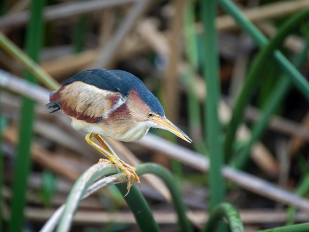
One of the first things we encountered was this Heron.  I thought at first it was a Green Heron, but got some help with the ID on Flickr.  It was small and still – and I glanced right past it without any recognition.  I’m glad MaryKate commented on it so I could make a photo!  Least Bitterns are supposed to be common in this type of environment, but I don’t  see them much.  I think because they’re so good at hiding!

Hunting HeronHunting Heron (Least Bittern)

Next we came up to this Mallard posing for me in the grass in front of some yellow flowers.

Mallard and flowersMallard

And there were several Wood Ducks.  I’ve seen them before at Greenwood and Mead Gardens, but hadn’t paid attention to their non breeding colors.  This young one is interesting and I’m looking forward to spring time when their plumage starts changing.

Young Wood DuckJuvenile Wood Duck

Here’s a bird that I’d never seen before or even heard of.

Swan-Goose (?)Swan Goose

Swan Geese are native to the Far East and have also been domesticated.  There were two, this one and another that was all white.  It’s likely they escaped or were released from captivity since they don’t occur naturally in the US.

This Mottled Duck was resting in a notch about seven feet above ground. It watched us as I made the photo, but didn’t seem nervous. The tree was right next to the sidewalk and it must be used to people nearby.

Sleepy DuckSleepy Duck

Unfortunately, there’s some bad news about the Lake Cherokee Mute Swan family.  There were initially three babies, but only one’s been seen lately.

From across the lake, MaryKate and I spotted two adults  but no babies.  We worried they’d lost the last cygnet too.  But when we got closer, we saw what was going on – Mom was riding the baby on her back!

Mute Swan Mom carrying babyMute Swan Mom carrying baby

We also saw Limpkins, Common Gallinules, Great Egrets, a second Mute Swan family (with four large juveniles!), Anhingas, and several turtles.  What a wonderful walk and what an unexpected abundance of things to experience and photograph!  Thanks for inviting me, MaryKate!

You can click on each of these images to view a larger version on Flickr.  And if you’re interested, I’ve started collecting my photos from here in this album on Flickr.

Thanks for stopping by and reading my blog. Now – go make some photos!

©2019, Ed Rosack. All rights reserved

Blue Cypress Lake Postcard

Hello loyal readers! This is the next entry in the occasional blog category called “Postcards” where I upload photos of Central Florida scenes – similar to ones you’d find on a postcard.

It’s easy to find all of these. Just use the “Places / Categories” pulldown menu over on the right side of the blog and select “Postcards”. If you’re viewing the site on a phone, you may not see that menu – in that case, just type “postcards” into the search box.

Blue Cypress ShorelineBlue Cypress Shoreline

I made this image in April of 2017 from a pontoon boat in Blue Cypress Lake, near Vero Beach, Florida.  This wonderful lake is part of the St. Johns River headwaters.  Here’s a link to all the posts I’ve written about it: https://edrosack.com/category/photo-ops-in-florida/blue-cypress-lake/.  And you can view other photos from there at this link: https://www.flickr.com/photos/edrosack/albums/72157630027829768.

It’s a 2 frame vertical panorama shot with an infrared modified camera, handheld with a 24 mm equivalent lens at f/3.5,  ISO 200 at 1/800 sec. I processed the photo and converted it to Black and White using Lightroom and Photoshop. You should be able to click on it to go to Flickr and then select the download symbol below and to the right of the photo. I hope you like it!

Thanks for stopping by and reading my blog. Now – go make some photos!

©2019, Ed Rosack. Creative Commons, Attribution-NonCommercial-ShareAlike 4.0 International license

Note: Items in my blog that are marked with a Creative Commons license are available in high resolution for you to download for your personal use. Please visit this page to see details and restrictions that apply: https://creativecommons.org/licenses/by-nc-sa/4.0/.

Merritt Island 6-9-19

It’s getting to be that time of year down here in Central Florida:  Hot, muggy, and buggy, with many of the birds hiding or gone.

None the less, Kevin K. and I went over to Merritt Island last week to see what’s going on. Our first stop was along the Indian River at the Titusville Marina.  Clouds on the horizon helped the sun add some color to the morning.

Dawn, down on the riverDawn, down on the river

On Black Point Wildlife Drive, our most interesting find was this Stilt wading through calm water and good light.  I like this close up, but I wish I’d also made a frame including the whole reflection.

Black-necked StiltBlack-necked Stilt

As we left, this healthy looking animal was calmly marching across the black top.  There were no cars coming from either direction, so we could stop and give him the right of way.  And make a photo too!

Why did the gator cross the road?Why did the gator cross the road? It didn’t say, but the grass is green on the other side!

There are still some interesting birds at MINWR.  For instance, Pat H. found a Clapper Rail on BPWD a couple weeks ago.  But it seems like most of our winter visitors have moved on.  Maybe we need to move on too and look for photo ops in other spots until it starts cooling off again.

You can click on these images to view a larger version on Flickr. Thanks for stopping by and reading my blog. Now – go make some photos!

©2019, Ed Rosack. All rights reserved

Seen in St. Augustine

Lynn and I spent a couple of days in St. Augustine, Florida last week.  It’s been two years since I last wrote about it (in this post), but it’s still a photo rich environment.  Here’s a sample of the images I made there this time.

Columbia Restaurant interiorColumbia Restaurant interior.  We usually stop by this place for the food, but the inside is lovely too!

Memorial Presbyterian Church DomeMemorial Presbyterian Church Dome.  We rode the Old Town Trolley around again and got off at this stop to see this beautiful church.  Henry Flagler built it in the 1890s as a memorial to his wife.

Santa Maria Restaurant>Santa Maria Restaurant Ruins. Our trolley guide told us it has too much hurricane damage to repair. It’s going to be demolished soon and replaced with a new restaurant

Flower BoxFlower Box.  I like to watch for interesting doors and windows when I walk through town.  This is one example.

Golden mooring morningGolden mooring morning.  Lynn used some points to help us splurge on a waterfront room.  I made this from our balcony.

RefreshmentsRefreshments – Make the photo, then drink the subject. It’s important to get the sequence correct!

What a photogenic place!  They’ve done a wonderful job recovering from Hurricane Irma.  It’s hard to see any remaining damage other than the Santa Maria Restaurant.  You can browse all my St. Augustine blog posts at this link.  And you can view my other St. Augustine images in this album on Flickr.

Thanks for stopping by and reading my blog. Now – go make some photos!

©2019, Ed Rosack. All rights reserved